
ファイル:Satellite image of Iceland in September.jpeg

このプレビューのサイズ: 800 × 600 ピクセル。 その他の解像度: 320 × 240 ピクセル | 640 × 480 ピクセル | 1,024 × 768 ピクセル | 1,280 × 960 ピクセル | 2,400 × 1,800 ピクセル。
元のファイル (2,400 × 1,800 ピクセル、ファイルサイズ: 653キロバイト、MIME タイプ: image/jpeg)
ウィキメディア・コモンズのファイルページにある説明を、以下に表示します。
|
概要
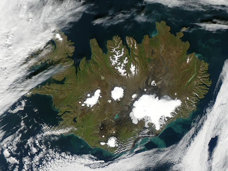
| 解説 | Summer is winding to a close on September 9, 2002, but even Iceland is still showing some summer color, its perimeter tinged with green, while its large permanent ice caps stand out brightly against the volcanic rock surrounding them. The largest ice cap, Vatnajokull, actually rests on top of three active volcanoes. The heat from these volcanoes causes the underside of the ice cap to melt, slowly filling the calderas. Eventually the caldera spills over and releases a torrent of water known as a glacial melt flood. This volcanic activity happens because a tectonic boundary runs roughly northeast-southwest through the island country, and the two plates are pulling away from each other, causing magma to well up from deep in the Earth. By mid-October, the northern part of the island is snow covered, and by late October, the entire island is wearing its wintry blanket. The brightly colored lakes and coastal waters are the result of very fine, and highly reflective sediment that is ground to bits by the immense weight of the glaciers and washed out with glacial runoff. These images were captured by the Terra and Aqua satellites. |
| 日付 | 2002年9月9日 |
| 原典 | http://visibleearth.nasa.gov/view_rec.php?id=4702 |
| 作者 | Jacques Descloitres, MODIS Rapid Response Team, NASA/GSFC |
| このファイルはアメリカ航空宇宙局(NASA)によって作成されたものです。NASAの著作権の方針では、特記事項が無い場合、NASAの資料はパブリックドメインとなります。 (詳しくはTemplate:PD-USGov、NASAの著作権の方針について(英語)又はジェット推進研究所(JPL)の画像使用に関するガイドライン(英語)をご覧ください。) |
||
 |
注意事項:
|
ファイルの履歴
過去の版のファイルを表示するには、その版の日時をクリックしてください。
| 日付と時刻 | サムネイル | 寸法 | 利用者 | コメント | |
|---|---|---|---|---|---|
| 現在の版 | 2004年11月8日 (月) 04:59 | | 2,400 × 1,800 (653キロバイト) | Ævar Arnfjörð Bjarmason |
ファイルの使用状況
このファイルを使用しているページはありません。
グローバルなファイル使用状況
以下に挙げる他のウィキがこの画像を使っています:
- ast.wikipedia.org での使用状況
- azb.wikipedia.org での使用状況
- be.wikipedia.org での使用状況
- bn.wikipedia.org での使用状況
- da.wikipedia.org での使用状況
- de.wikipedia.org での使用状況
- dz.wikipedia.org での使用状況
- el.wikipedia.org での使用状況
- eo.wikipedia.org での使用状況
- es.wikipedia.org での使用状況
- fr.wikipedia.org での使用状況
- hr.wikipedia.org での使用状況
- hu.wikipedia.org での使用状況
- hy.wikipedia.org での使用状況
- is.wikipedia.org での使用状況
- is.wikibooks.org での使用状況
- it.wikipedia.org での使用状況
- it.wikibooks.org での使用状況
- it.wikiversity.org での使用状況
- ka.wikipedia.org での使用状況
- lt.wikipedia.org での使用状況
- nn.wikipedia.org での使用状況
- no.wikipedia.org での使用状況
- oc.wiktionary.org での使用状況
- pl.wikipedia.org での使用状況
- pt.wikipedia.org での使用状況
- ru.wikipedia.org での使用状況
このファイルのグローバル使用状況を表示する。