
ファイル:Montreal1764CedarsDetail.png

このプレビューのサイズ: 800 × 523 ピクセル。 その他の解像度: 320 × 209 ピクセル | 640 × 418 ピクセル | 1,067 × 697 ピクセル。
元のファイル (1,067 × 697 ピクセル、ファイルサイズ: 1.19メガバイト、MIME タイプ: image/png)
ウィキメディア・コモンズのファイルページにある説明を、以下に表示します。
|
概要
| 解説 |
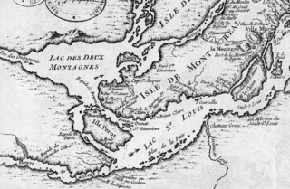
English: This is a detail of the original source map, cropped to depict the western part of the Isle of Montreal and immediately surrounding mainland as far as Les Cèdres. The map's caption reads "Montreal et ses Environs" (Montreal and its environs). It depicts a number of places relevant to the 1776 Battle of the Cedars. |
| 日付 | |
| 原典 | Bibliothèque Nationale de France http://gallica2.bnf.fr/ark:/12148/btv1b67001778 |
| 作者 | Bellin, Jacques-Nicolas, for the Kingdom of France |
| その他のバージョン | IsleDeMontreal1764.png |
ライセンス
|
この著作物は、著作権の保護期間が著作者の死後100年以下である国・地域においてパブリックドメインの状態にあります。 | |
| このファイルは著作権法の既知の制約(隣接権や関連する権利を含む)から自由であると特定されています。 | |
ファイルの履歴
過去の版のファイルを表示するには、その版の日時をクリックしてください。
| 日付と時刻 | サムネイル | 寸法 | 利用者 | コメント | |
|---|---|---|---|---|---|
| 現在の版 | 2009年1月23日 (金) 22:57 | | 1,067 × 697 (1.19メガバイト) | Magicpiano | {{Information |Description={{en|1=This is a detail of the original source map, cropped to depict the western part of the Isle of Montreal and immediately surrounding mainland as far as Les Cèdres. The map's caption reads "Montreal et ses Environs" (Mont |
ファイルの使用状況
以下のページがこのファイルを使用しています:
グローバルなファイル使用状況
以下に挙げる他のウィキがこの画像を使っています:
- ar.wikipedia.org での使用状況
- en.wikipedia.org での使用状況
- es.wikipedia.org での使用状況
- it.wikipedia.org での使用状況
- nl.wikipedia.org での使用状況
- www.wikidata.org での使用状況
- zh.wikipedia.org での使用状況